Every few years a place in Việt Nam stops being a destination and becomes a verb. Ten years ago hardly anyone outside the country had heard of Hà Giang; today “doing the loop” is a fixture of backpacker itineraries, sold in every hostel lobby in Hà Nội’s Old Quarter. The landscape has earned it. What has not caught up is the way most people ride it, which is too fast, in too few days, chasing a checklist of photo stops. The organising idea of this post is simple: the Hà Giang loop is a road, not a list, and it rewards whoever gives it the most time.
What the loop actually is
The loop is a circuit of mountain roads that starts and ends in Hà Giang town, climbs onto the Đồng Văn Karst Plateau and runs along the edge of the Chinese border. The plateau was recognised as a UNESCO Global Geopark in 2010, and it looks the part: grey limestone broken into cones and blades, maize planted in pockets of soil between the rocks, and stone-walled Hmông houses that seem to grow out of the hillside.
Guides disagree on the distance, because nobody rides exactly the same loop. Expect somewhere around 300–350 km for the classic circuit and more with detours such as Du Già or the valley around Lũng Cẩm. A heads-up for anyone reading older guides: since the 2025 provincial merger, Hà Giang is no longer a province of its own. The whole area now belongs to an enlarged Tuyên Quang province, though everyone, signs included, still calls the route the Hà Giang loop.
The road is the destination
The famous stops are worth seeing. Quản Bạ Heaven’s Gate is the first big view over the “fairy mountains”. The Vương family palace at Sà Phìn is a stone-and-timber mansion built in the early twentieth century for the Hmông lords who once ran the plateau. The national flag tower at Lũng Cú stands close to the country’s northernmost point. Đồng Văn old town has a Sunday market that pulls in villages from across the district.
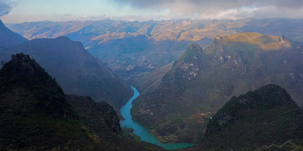
Then there is Mã Pí Lèng, the stretch of roughly 20 km between Đồng Văn and Mèo Vạc that clings to a cliff high above the jade-green Nho Quế river. It was cut by hand as part of the “Happiness Road” built in the late 1950s and 1960s, and the road’s monument records that people died building it. You can drop down to the river for a boat trip through Tu Sản canyon, which locals will tell you is the deepest in Southeast Asia. The view from the top still beats the view from the water.
None of these places is really the point, though. The point is what happens between them: a woman herding goats on a road with no barrier, children walking home from school along a ridge, a valley that opens up around a bend you had no reason to expect. On a three-day schedule you spend those hours watching the tarmac. On four or five you get to look up.
Rider or passenger?
This is the most important decision of the trip, so here is the honest version. Unless you hold a motorbike licence at home, a valid international permit (Việt Nam recognises the 1968 Convention IDP, not the 1949 one that several English-speaking countries issue) and real experience on mountain roads, do not ride yourself. Hire an “easy rider”, a local driver who takes you as a passenger. The roads are steep and narrow, the trucks don’t slow down, and the weather can turn a hairpin to mud within an hour. Police checkpoints on the loop do check papers, and travel insurance will not cover an unlicensed rider. After a British teenager was killed on the loop in April 2026, provincial authorities tightened the rules on tour operators. Pick a licensed company and ask what happens if someone is hurt.
Riding pillion is not a lesser experience. With both hands free and your eyes off the road, you see more of the landscape than the rider does.
Practical notes
- Getting there: Hà Giang town is roughly 300 km from Hà Nội. Sleeper buses and limousine vans run day and night and take six to eight hours. The expressway only covers the first part, and the last stretch is a slow two-lane highway.
- How long: Three days is the minimum and four is better. Add a fifth if you want the Du Già detour or a Sunday in Đồng Văn.
- When to go: October and November are the classic months, with dry roads, clear air and the pink buckwheat flowers (tam giác mạch). Guides put the peak in early to mid-November. Some of the most-photographed fields are planted for visitors and charge a small entry fee, so they are pretty but staged. Spring brings peach and plum blossom. In summer, landslides are a real risk. In winter it gets properly cold, sometimes with frost on the plateau.
- What to eat: thắng cố (a horse-meat stew, an acquired taste) at a market, bánh cuốn with egg in Đồng Văn, mèn mén (steamed maize), and cháo ấu tẩu, a bitter, warming rice porridge. Only order the porridge from established stalls, because the root it is made from is poisonous unless prepared properly. Go easy on the corn liquor if you are riding the next morning.
- Downsides: The famous viewpoints are crowded with tour convoys by mid-morning. Some homestays on the main route have become party hostels. And the loop is genuinely dangerous for inexperienced riders. Leave early, sleep in the quieter villages, and give yourself one more day than you think you need.
Cover photo: the Nho Quế river seen from the Mã Pí Lèng pass by NKSTTSSHNVN, CC BY-SA 4.0, via Wikimedia Commons.
